AGTEK software logo
Powered by AGTEK
ASPE Certified Professional Estimator (CPE) Certification

Earthwork Takeoff Services

Full-Scope Sitework & Civil Takeoffs

We provide accurate earthwork and material takeoffs that contractors rely on to price job with confidence. Using AGTEK 4D, we convert 2D civil drawings into precise 3D models to calculate cut-and-fill, excavation, grading, and dirt movement with full traceability.

Cut & Fill / Bulk Earthwork Volumes

Bulk cut and bulk fill volumes are calculated from existing vs proposed grade models to produce accurate cut/fill balance for bidding. Reports include surplus or deficit quantities, borrow requirements, and practical material movement allowances, including on-site rehandling where it affects cost and logistics.

Excavation

Our excavation takeoff covers building pads, basements, pits, and general earthwork, along with structural excavations for footings, foundations, pile caps, and grade beams. Over-excavation is included when specified, and rock or hard material excavation is quantified separately when identified in the project documents.

Backfill & Compacted Fill

Backfill takeoffs include structural backfill to walls and foundations and trench backfill (initial and final) aligned with compaction requirements. Engineered fill, embankments, and compacted lifts are quantified with a clear split between imported material and re-use of excavated material for clean pricing.

Scope of work

Scope of work

Utility and Backfill

We provide utility and dirt takeoff for storm, sewer, water, electrical, telecom and gas based on plan details and standard sections. Where specified, bedding, surround, and pipe zone quantities are included, with trench width and depth aligned to drawings for precise totals.

Disposal / Export / Import

Topsoil stripping quantities are measured by defined limits, including stockpile and re-spread where required for BOQ pricing. Clearing and grubbing allowances and formation preparation items (such as proof-roll) are included when shown or measurable in the project documents.

Grading & Leveling

Rough grading and fine grading quantities are developed within defined site boundaries, including slopes, berms, swales, ditches, and drainage shaping. Subgrade shaping under pavements and hardscape areas is also quantified where applicable to support accurate earthwork pricing.

Site Preparation

Site preparation quantities include clearing and grubbing, removal of vegetation and obstructions, and preparation of the site prior to excavation and grading. Where shown or specified, topsoil stripping, stockpiling, and initial formation preparation are quantified to ensure early-stage earthwork activities are accurately priced and coordinated.

Erosion & Sediment Control

Erosion and sediment control quantities include temporary earth berms, swales, ditches, and grading required to manage runoff during construction. Where shown on the plans, earthwork for sediment basins, traps, and temporary drainage features is quantified to support compliance and site stability.

earthwork quantity takeoff_3D dirt model

What do we quantify in Earthwork Quantity Takeoff

Using AGTEK 4D, we generate surface-to-surface and linework-based earthwork quantities that are consistent, traceable, and bid-ready. Our takeoffs are built from existing conditions (EG) and proposed design surfaces (FG/SG) to deliver reliable earthwork and sitework volumes.

Our Deliverables for Earthwork Analysis and Material Takeoff (AGTEK)

Earthwork Volume Report

A complete earthwork summary that consolidates mass earthworks, grading quantities, and key measurement assumptions. This report is designed for estimating workflows and can be aligned with bid forms, alternates, and scope narratives.

Earthwork 3D Model (Agtek)

A structured 3D surface model built from plan data, representing existing and proposed grades. This model supports coordination, quick checks, and constructability reviews—especially when comparing grading intent against site constraints.

Cut Fill 3D View Map

A visual 3D map that highlights cut and fill zones with easy-to-interpret grading surfaces. This helps teams validate takeoff assumptions, identify heavy earthwork areas, and communicate scope quickly with owners, GCs, and subcontractors.

Earthwork Material Quantity Takeoff

Material quantities for earthwork operations, including measurable volumes that support planning for import/export, staging, and material management. This deliverable is structured to reduce uncertainty around what needs to move, where, and how much.

Underground Utility Takeoff Report

A quantified utility scope takeoff including trenching-related quantities where applicable. The report supports pricing for underground work by providing measurable quantities tied to plan geometry and standards-based trench parameters.

Underground Utility 3D Model and Marked Plan

Our Underground Utility 3D Model and Marked Plan (built in AGTEK) provide both a clear visual model and easy-to-review drawings for underground scope coordination. The 3D model shows proposed utility routing and depth relationships across the site to help teams understand alignments, crossings, and placement relative to grading, while the marked plan delivers annotated sheets that highlight utility runs, key tie-in points, crossings, and trench extents.

Underground Utility Conflict Identification

We provide detailed utility analysis to identify potential conflicts between existing underground utilities and proposed construction elements. Our deliverable highlights clashes in water, sewer, gas, electrical, and telecom lines, helping contractors and engineers avoid costly delays and redesigns.

Trench Volume and Depth Bracket Summary Reports

A focused trench report summarizing trench excavation/backfill volumes by utility run or system. It supports accurate trench pricing, bedding considerations, and production planning—especially on utility-heavy sites.

Google Earth 3D Overlay

A presentation-ready overlay showing the modeled site in a Google Earth 3D context. This helps stakeholders understand site grading and utility intent relative to real-world surroundings, access points, and constraints—ideal for coordination and client communication.

Explore grading, excavation, earthwork analysis, and full-scope site and civil takeoffs samples.

How We Perform Earthwork Takeoffs

Review project documents

Grading plans, profiles, sections, notes, and earthwork specs to confirm scope, datum, and measurement basis.

Build the Existing Ground (EG)

Build the Existing Ground (EG) surface in AGTEK 4D using contours, spot levels, break lines, and defined boundaries.

Define phase and area boundaries

Define phase and area boundaries (pads, roads, lots, detention, utilities zones) to report quantities exactly the way estimators price them.

Run surface-to-surface volume calculations

Run surface-to-surface volume calculations to produce total cut, fill, and net balance—plus area-wise and phase-wise summaries.

Quantify detailed earthworks

Quantify detailed earthworks where required: trench excavation takeoff, bedding zones, structural backfill, over-excavation, and unsuitable material replacement (based on details/specs).

Validate and cross-check:

Confirm elevations, slopes, boundary limits, and reconciliation against key sections/profiles to avoid scope gaps.

Deliver bid-ready outputs

AGTEK reports, quantity sheets, and marked-up exhibits showing assumptions, limits, and traceable measurements.

Why choose us for Earthwork Takeoff

We deliver accurate earthwork estimating services that contractors can bid with confidence. Our takeoff process is built around AGTEK Gradework, high quality 3D modeling standards, and estimator-focused reporting—so there are no surprises during construction or project bidding.

AGTEK 4D–Driven Accuracy

We model existing and proposed surfaces precisely, using break lines, boundaries, and daylight controls to produce reliable cut-and-fill volumes and defensible mass-haul balances.

Risk-Focused Earthwork Analysis

We identify surplus/deficit material, import/export needs, over-excavation, and hard-dig allowances early—helping you manage cost and schedule risk before bid day.

Utility & Detail-Level Precision

Beyond bulk earthworks, we quantify utility trenches, bedding zones, structural backfill, and subgrade shaping with linework and section-based accuracy.

Fast Turnaround Without Compromising Quality

Our standardized AGTEK workflows allow quick delivery while maintaining consistent checks across surfaces, boundaries, and reports.

Our Project Portfolio of Earthwork Take-offs

earthwork takeoff services_3D Agtek model
earthwork estimating services

Experts in 3D Dirt Models, Excavation Takeoff , Earthwork Volumes, Utility and Complete Civil Takeoffs

We deliver precise 3D dirt model, excavation quantity takeoff, utility takeoff with 3D model, and full-scope civil takeoff that eliminate guesswork, reduce costs, and keep your earthmoving projects on budget.

Who This Earthwork Takeoff Service Is For

Our earthwork takeoff services is designed for professionals who require accurate, bid-ready quantities to control cost, risk, and construction planning.

Software & Tools We Rely On

We convert 2D civil drawings into accurate 3D AGTEK models and deliver bid-ready earthwork quantity reports to help contractors price sitework competitively.

earthwork takeoff_3d model view_Agtek software

AGTEK 4D: Surface modeling and cut/fill volume calculations with phase-wise reporting.

cut fill 3d view AGTEK_residential community

Bluebeam Revu: Plan review, detail verification, and clean markups to support quantities.

Project Types We Cover

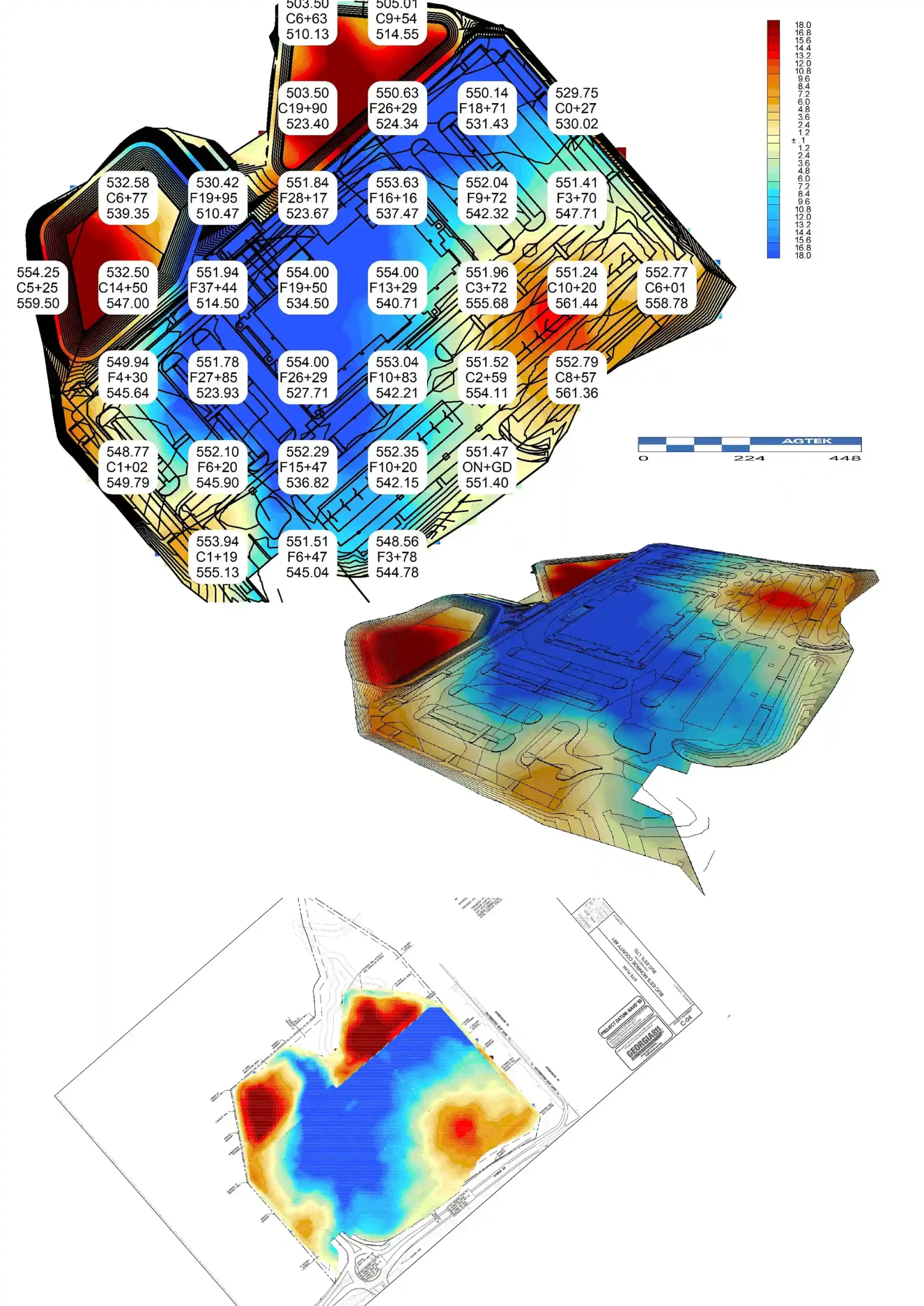
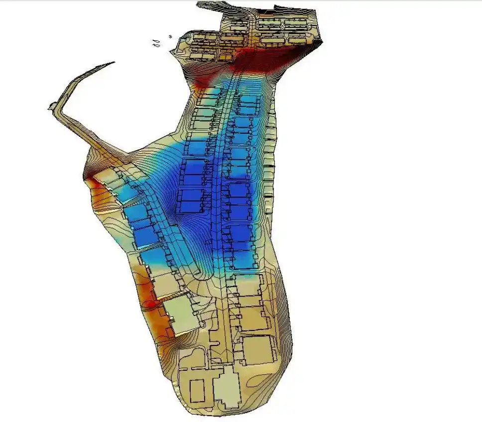
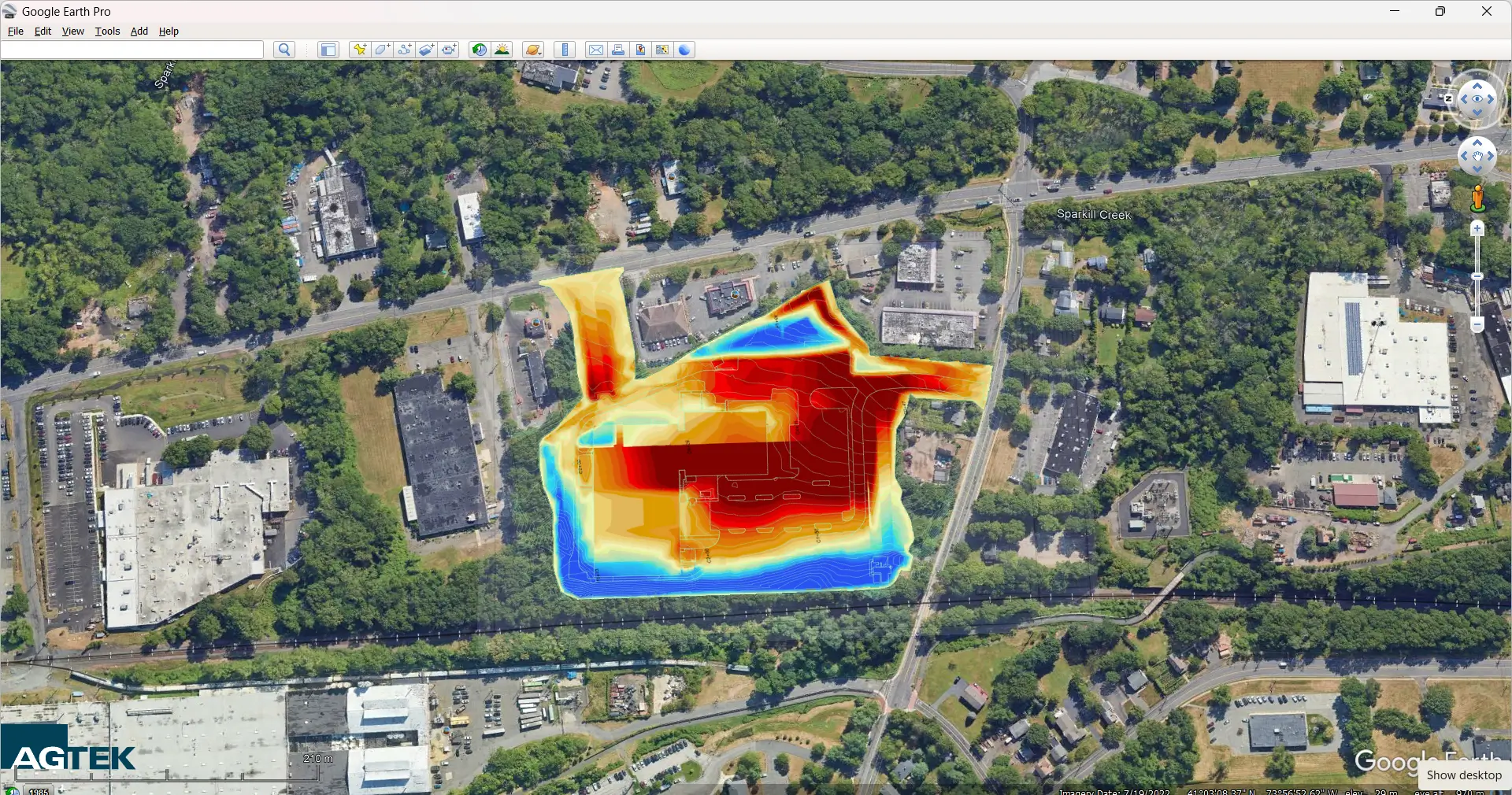
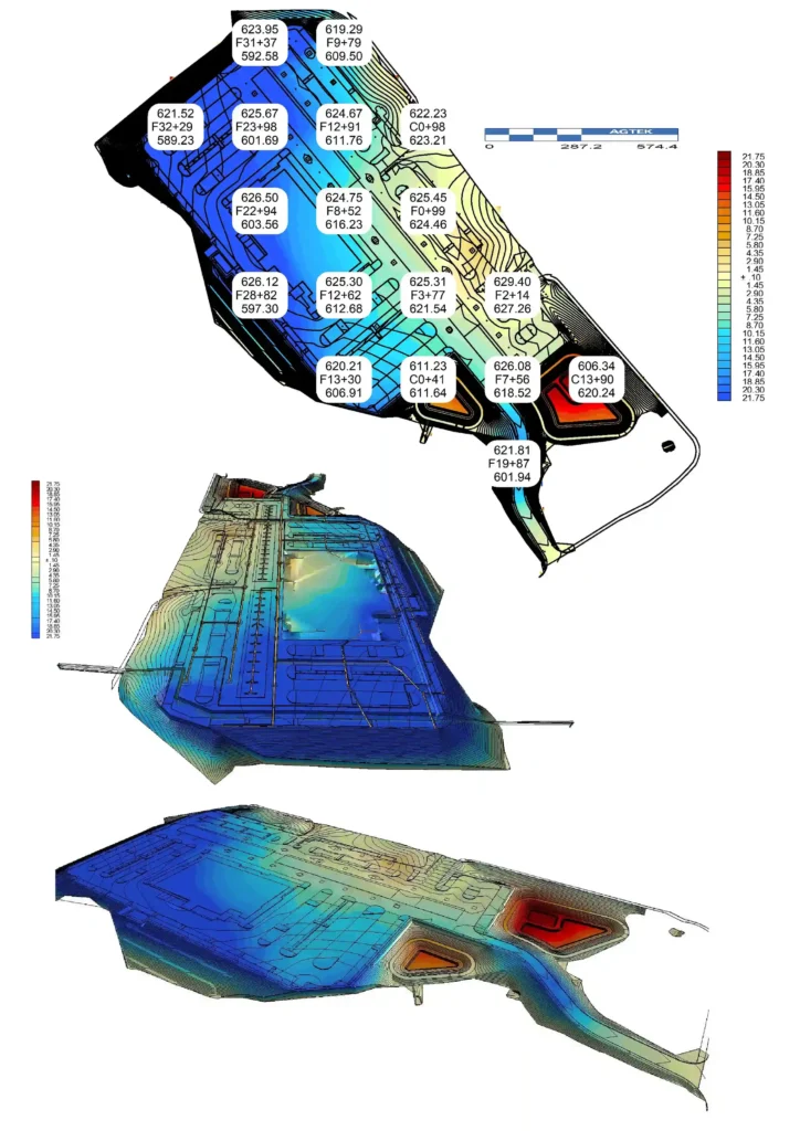
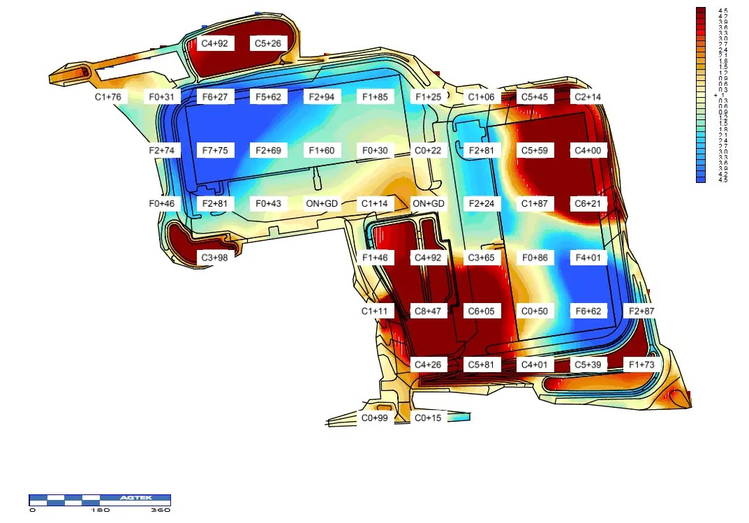
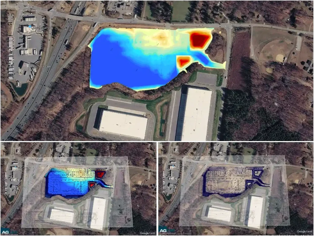
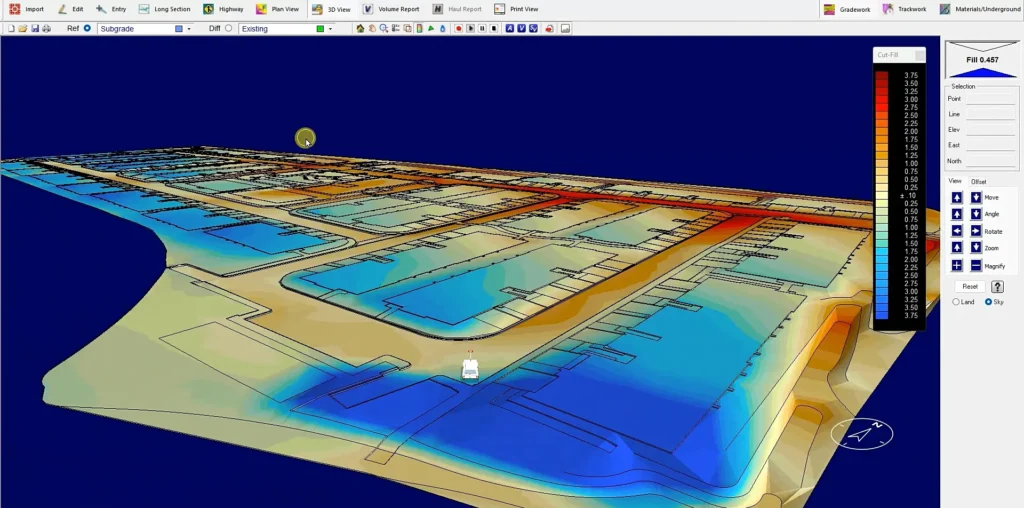
Our Agtek 3D earthwork takeoff services focus exclusively on projects where accurate cut-and-fill, excavation, and grading quantities are critical to cost control. This includes developments with significant mass earthworks, building pad preparation, utility trenching, roadway subgrades, drainage works, and site formation activities, where precise volume modeling directly impacts pricing, material movement, and construction sequencing.

Earthwork Takeoff Process

Our streamlined process ensures accurate, reliable earthwork calculations for your construction projects. From plan submission to final report delivery, we handle every detail with precision.

1

Send Us Your Plans

Upload your project plans in PDF or CAD format through our secure portal. We accept all major file types including DWG, DXF, PDF, and TIFF.

2

We Review & Quote

Our expert team analyzes your plans, assesses project complexity, and provides a transparent, competitive quote for our earthwork takeoff services.

3

Accept & Pay

Review our proposal and accept the terms. Make secure payment through our encrypted payment gateway to initiate the earthwork takeoff process.

4

We Perform Takeoff

Our certified professionals use advanced software to perform accurate earthwork calculations, including cut/fill volumes, material quantities, and grade analysis.

5

Receive Detailed Reports

Get comprehensive, easy-to-understand reports including volume summaries, cross-sections, 3D visualizations, and exportable data for your project management.

What Our Clients Say

Leading construction and engineering firms across the United States trust our precise earthwork takeoff services.

Earthwork Takeoff Services
The accuracy of their earthwork takeoff services saved us over $200K on our Denver highway expansion project. Their detailed cut/fill analysis was spot-on with the actual site conditions, allowing us to optimize our equipment allocation and reduce material waste significantly.

Michael Reynolds

Project Director

Western States Construction, Colorado
Grading Volumes
Their grading volume calculations for our Texas commercial development were impeccable. The 3D visualization helped our team identify potential drainage issues before breaking ground, saving us weeks of rework and unexpected costs.

Sarah Chen

Lead Civil Engineer

Lone Star Development Group, Texas
Underground Utility Takeoff
We've used their underground utility takeoff services for three major projects now. Their ability to identify and map existing utilities prevented costly delays and redesigns. The accuracy of their subsurface modeling is exceptional.

David O'Connell

Utilities Manager

Pacific Utilities Inc., California
Civil Work Takeoff
The comprehensive civil work takeoff for our Florida municipal project was delivered ahead of schedule with exceptional detail. It integrated perfectly with our BIM workflow, streamlining coordination between all project stakeholders.

James Peterson

Senior Estimator

Sunshine State Contractors, Florida
Earthwork & Grading Combined
For our Michigan industrial park project, their combined earthwork and grading analysis provided the most accurate bid package I've seen in 20 years. Exceptional service that gave us a competitive edge in the bidding process.

Robert Hayes

Operations Director

Great Lakes Infrastructure, Michigan
Earthwork Takeoff Services
Their earthwork takeoff precision helped us complete the Arizona solar farm project 15% under budget. The digital terrain modeling was so accurate we reduced our contingency allowance significantly.

Amanda Rodriguez

Project Manager

Desert Sun Energy, Arizona

Frequently Asked Questions

An earthwork takeoff is the process of calculating cut, fill, excavation, grading, and material movement quantities from civil drawings to support accurate sitework pricing.

We quantify the numbers contractors price every day: cut-and-fill, mass grading, excavation, backfill, subgrade prep, utility trenching, and import/export quantities.

We primarily use AGTEK 4D and Bluebeam for surface modeling and volume calculations, supported by Bluebeam Revu for plan review and verification.

Yes. We convert 2D civil plans, profiles, and sections into accurate 3D models for reliable earthwork quantity calculations.

Accuracy is ensured through surface modeling, defined boundaries, cross-checks against plans and profiles, and clear documentation of assumptions.

Yes. Our takeoffs are organized area-wise and phase-wise with clear reporting—so your estimating team can price quickly without guessing.

Yes. Quantities can be broken down by phase, building pad, roadway, lot, or work zone, making pricing and sequencing easier for your team.

Where required, assumptions are clearly stated so you can apply your own production rates, pricing, or soil factors with confidence.

Regions We Serve

We provide construction estimating services across all 50 U.S. states and throughout Canada, supporting sitework and civil projects nationwide. In the United States, we frequently work in the most populated states, including California, Texas, Florida, New York, Pennsylvania, Illinois, Ohio, Georgia, North Carolina, Michigan, New Jersey, Virginia, Washington, Arizona, Massachusetts, Tennessee, Indiana, Missouri, Maryland, Wisconsin, Colorado, Minnesota, South Carolina, Alabama, and Louisiana. In Canada, we support projects across multiple provinces, delivering accurate, AGTEK-based earthwork quantities regardless of location.